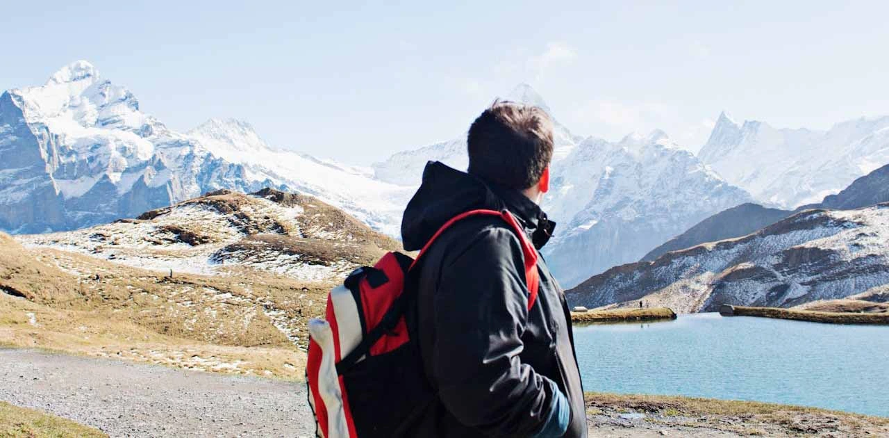
Tucked away in western Wyoming, the Wind River Range is a backpacker’s paradise—remote, rugged, and incredibly scenic. With more than 2.25 million acres of wilderness, the range offers some of the most stunning alpine trekking in the Lower 48. From towering granite spires to glacial valleys, the Wind Rivers provide an ideal setting for those looking to escape the crowds and immerse themselves in raw, untouched nature.
This guide is for hikers and backpackers—especially budget-minded adventurers, solo travelers, and nature lovers—who want to explore this lesser-known gem. You’ll find practical tips on when to go, how to get there affordably, and why this destination is worth the effort. Whether you’re planning a three-day loop or a weeklong backcountry expedition, this post will help you prepare for a memorable experience in one of America’s wildest places.
Why Backpacking in The Wind River Range, Wyoming Is Worth It
Backpacking in the Wind River Range isn’t just about the views—although the views are unforgettable. It’s about solitude, challenge, and connection to a landscape that feels almost prehistoric. Unlike national parks, the Winds aren’t lined with pavement and visitor centers. Here, you’ll find granite peaks, alpine lakes, glaciers, and miles of untouched forest with few human-made interruptions.
The Wind Rivers stretch over 100 miles through the Bridger-Teton and Shoshone National Forests, forming part of the Continental Divide. Hikers often compare its terrain to the Sierra Nevada or parts of the Rockies, but the Winds feel more secluded. The region is home to 46 peaks over 12,000 feet, hundreds of glacier-fed lakes, and some of the largest glaciers in the American Rockies—including Gannett Glacier. For those looking to escape busy trails and reconnect with wilderness, it’s hard to imagine a better place.
In addition, the Wind River Range is a top destination for experienced backpackers who want a mix of rugged alpine trekking and remote wilderness camping. But you don’t need to be a pro to enjoy it—many routes are suitable for beginners or intermediate hikers with the right gear and planning.
Best Time to Go Backpacking in The Wind River Range, Wyoming
Backpacking in the Winds is seasonal. Due to high elevation and snowpack, most trails don’t fully open until late June or even early July, depending on the year. However, the season stretches into late September for those willing to face cooler nights.
Here’s a closer look at what each part of the season offers:
- Mid-July to Late August: This is the prime hiking season. Trails are mostly clear of snow, alpine wildflowers are in full bloom, and most routes are accessible. However, it’s also the busiest time, especially around popular areas like Titcomb Basin and Cirque of the Towers. Afternoon thunderstorms are common, so hikers should plan early starts.
- Early September to Mid-October: This shoulder season is ideal for those seeking solitude. Bugs are gone, the air is crisp, and fall colors begin to show. However, weather becomes more unpredictable. Snow can return early, so always check forecasts before heading out.
- Late June to Early July: This period can be risky, as many trails still have snowfields, swollen river crossings, and muddy paths. That said, some lower-elevation routes become accessible earlier, and it’s a good time for short trips if you’re prepared for variable conditions.
For budget travelers, early September offers a sweet spot—fewer crowds, cheaper accommodations in nearby towns, and good weather if timed right. Always be prepared for cold nights, especially above 10,000 feet.
How to Get There (and Around on a Budget)
The Wind River Range is remote, and getting there requires a bit more effort than visiting a typical national park. But with planning, it’s absolutely doable on a budget.
The main gateway towns are Pinedale, Lander, and Dubois, depending on which trailheads you plan to use. These towns sit on the western and southeastern edges of the range and offer access to trailheads like Elkhart Park, Big Sandy, Green River Lakes, and Dickinson Park.
Here are the most common ways to reach the Winds:
From Major Cities:
- From Salt Lake City, Utah (approx. 4.5 hours): This is the most popular major city to fly into. It has affordable flights and car rental options. From there, you can drive northeast to Pinedale or Farson.
- From Denver, Colorado (approx. 6–7 hours): Another option with major airport access, but travel time is longer.
- From Jackson, Wyoming (approx. 2–3 hours): Closer, but often more expensive in terms of flights and lodging.
Transportation Tips for Budget Travelers:
- Car Rentals: Renting a car is usually the easiest option. If you’re traveling in a group, splitting the cost makes this more affordable. Compact cars work fine for most trailheads, but high-clearance is useful for rougher roads like Big Sandy.
- Rideshare and Shuttles: There are limited shuttle services in the area. Great Outdoor Transportation Company and some local outfitters offer point-to-point trailhead shuttles (especially for through-hikes). Book in advance and expect seasonal operation.
- Hitchhiking: Some backpackers use this option for getting back to their car after a point-to-point route. While not guaranteed, the hiker-friendly local culture makes it a possibility. Still, it’s best to have a backup plan.
There is no public transit directly to Wind River trailheads, so if you’re coming without a car, you’ll need to rely on shuttle coordination or local taxi services from towns like Pinedale or Lander.
Budget Tip: If you’re flexible, flying into Salt Lake City and driving with a few friends will usually be the most cost-effective way to get to the Winds. Booking your rental car and lodging well in advance—especially in summer—can also save you money.
Suggested Backpacking Itineraries
The Wind River Range offers enough trail variety to suit almost any kind of backpacker—from first-timers to seasoned long-distance hikers. Below are three sample itineraries to help you plan based on your time, experience, and goals.
3-Day Intro Trip: Elkhart Park to Seneca Lake Loop
This is a great starter route with dramatic scenery and moderate elevation gain.
- Day 1: Start at Elkhart Park and hike roughly 8 miles to Seneca Lake. It’s a gentle but steady climb through meadows and forest. Camp near the lake.
- Day 2: Day hike from Seneca Lake to Island Lake (about 4–5 miles roundtrip), one of the most iconic alpine lakes in the Winds. Return to camp or camp closer to Hobbs or Little Seneca Lake.
- Day 3: Hike back out to Elkhart Park.
This route stays below the most rugged terrain while still offering views of peaks like Fremont and Jackson.
5-Day Moderate Trip: Big Sandy Trailhead to Cirque of the Towers Loop
Perfect for those with a bit more experience and time.
- Day 1: Begin at Big Sandy Trailhead. Hike 6–7 miles to Big Sandy Lake. Camp near the lake or head slightly uphill to a quieter spot.
- Day 2: Hike over Jackass Pass to Lonesome Lake in Cirque of the Towers. Camp with stunning views.
- Day 3: Explore day hikes within the Cirque or head north to Shadow Lake via Texas Pass (steep but rewarding).
- Day 4: Continue through the Hailey Pass Loop or reroute back depending on conditions.
- Day 5: Return to Big Sandy Trailhead.
Cirque of the Towers is one of the most photographed areas in the Winds and well worth the effort.
7-Day Full Loop: Green River Lakes to Titcomb Basin and Beyond
A classic high-alpine trek for more experienced backpackers.
- Day 1: Start at Green River Lakes. Hike along the Green River into the wilderness. Camp near Three Forks Park.
- Day 2: Climb into Peak Lake Basin. Be prepared for elevation gain and possible snowfields in early season.
- Day 3–4: Continue over Knapsack Col into Titcomb Basin—one of the most dramatic glacial valleys in the region. Spend time exploring side trails or resting.
- Day 5–6: Begin looping back toward Island Lake, then onward toward Seneca Lake.
- Day 7: Return via the Pole Creek Trail to the Elkhart Park Trailhead.
Note: This route involves a shuttle unless you loop carefully or arrange pickup at another trailhead.
Budget Accommodation Options
Affordable stays around the Wind River Range include established campgrounds, dispersed camping spots, and basic motels in gateway towns.
Top Camping Options:
- Elkhart Park Trailhead Campground: Basic, first-come, first-served. Free or low cost.
- Big Sandy Trailhead Campground: Another simple option with vault toilets. Limited space; arrive early in peak season.
- Fremont Lake Campground (Pinedale): Forest Service site with lake access and picnic tables, just 15 minutes from town.
If you need a night in town before or after your hike:
- Budget Lodging in Pinedale or Lander: Motels like Sundowner Station, Log Cabin Motel, or The Jackalope Motor Lodge offer simple rooms often under $100/night.
- Hostels and Bunkhouses: Check local outfitters; some offer shared bunkrooms or allow camping on their property.
Permits:
Currently, no general backcountry permit is required for overnight trips in most of the Wind River Range, but group size limits (usually 15 people max) and campfire regulations apply. Always check with Shoshone or Bridger-Teton National Forest offices for any updated rules, especially in sensitive areas like Cirque of the Towers.
Backpacking Costs in The Wind River Range, Wyoming
Backpacking in the Winds can be surprisingly affordable—especially for those with their own gear. Here’s a sample breakdown:
- Campground Fees: $0–$15 per night (many trailheads are free)
- Lodging (pre/post-hike): $70–$100 per night (budget motel)
- Transportation (from Salt Lake): $60–$100 in gas roundtrip or carpool
- Food: $10–$20 per day (backpacking meals, snacks)
- Gear Rental (if needed): Tent, sleeping bag, bear canister, and stove rental could run $100–$150 total for a multi-day trip
Estimated Daily Cost (with own gear): $30–$50
Estimated Daily Cost (with some rentals): $60–$80
Cost-Saving Tips:
- Travel with a group and split car rental or gas
- Buy backpacking meals in bulk or prep homemade dehydrated meals
- Use free dispersed camping sites before and after the trip
- Rent gear from local outfitters in Pinedale or online gear libraries to avoid buying expensive items
Must-Pack Essentials for The Wind River Range, Wyoming
Conditions in the Winds can shift fast. A clear morning can turn into a thunderstorm afternoon with wind, hail, or even snow at elevation. Pack light, but don’t cut corners on essentials:
- Backpack (40–60L) – Look for lightweight, well-fitted options with enough space for 5–7 days.
- Tent – A freestanding, 3-season tent with a full rainfly. (e.g., MSR Hubba Hubba or Big Agnes Copper Spur)
- Sleeping Bag – Rated to 20–30°F. Nights are cold, even in July.
- Sleeping Pad – Insulated inflatable pad adds warmth and comfort.
- Stove – Small canister stove like the Jetboil or MSR PocketRocket.
- Water Filter – Options like Sawyer Squeeze or Katadyn BeFree work well here.
- Bear Canister or Ursack – Required in some areas, always smart to carry for food safety.
- Clothing Layers – Merino base layers, mid-layer fleece or down, and a waterproof shell.
- Navigation Tools – Waterproof maps (Earthwalk Press) and GPS apps like Gaia GPS or AllTrails.
- Headlamp – Always pack extra batteries.
- First Aid Kit + Blister Care – Moleskin or leukotape is essential for long hikes.
Optional but helpful:
- Trekking poles for river crossings and long descents
- Bug net or head net during mosquito season (late June–August)
- Gaiters for snow or debris-filled trails
Many of these items can be linked to affiliate-friendly gear platforms like REI, Backcountry, or Amazon.
Top Things to Do for Backpackers
While hiking is the main draw, backpacking in the Wind River Range gives you front-row access to experiences far beyond simple trail mileage:
- Alpine Lakes: Visit pristine spots like Island Lake, Titcomb Basin, Shadow Lake, and Green River Lakes.
- Climb Fremont Peak or Bonney Pass: Non-technical but strenuous ascents with sweeping views.
- Watch Wildlife: Spot mule deer, moose, pika, marmots, eagles, and possibly bears in quiet valleys.
- Explore Glaciers: The Gannett Glacier, near Gannett Peak, is the largest glacier in the American Rockies.
- Rock Climbing: Cirque of the Towers and Mount Hooker are world-famous climbing areas. Even if you’re not a climber, watching others scale the walls is impressive.
The Winds don’t have coastal zones or tidepools like coastal parks, but their glacial lakes and high alpine plateaus offer equally rare and beautiful ecosystems.
Food and Water Tips for Backpackers
Backpackers need to carry all food into the Wind River Range—there are no on-trail shops or resupply points. Plan meals carefully and minimize waste.
Food Tips:
- Bring lightweight, high-calorie meals: oatmeal, pasta, rice, peanut butter, tortillas, and dehydrated meals work well.
- Repackage food into resealable bags for space and trash control.
- Store food properly in a bear canister or Ursack, and never leave anything scented in your tent.
Water Tips:
- The Winds are full of lakes, creeks, and meltwater streams. However, all water must be filtered or boiled.
- Good water sources include Seneca Lake, Island Lake, Green River, and countless streams along major trails.
- In late summer, some small creeks may dry up. Always fill up when you’re unsure about the next source.
- Carry at least 2–3 liters per person and know your refill points.
Safety Tips for Backpacking in The Wind River Range, Wyoming
Backpacking in the Wind River Range demands preparation. The terrain is remote, weather can shift without warning, and cell service is limited or nonexistent in most areas. Before setting out, always share your itinerary with someone you trust and carry a physical map along with a GPS-based app.
Trail safety is a major priority. Many routes involve steep climbs, stream crossings, or high-altitude travel above 10,000 feet. Early summer hikers may encounter lingering snowfields or slippery rock. Start early to avoid afternoon thunderstorms, especially in July and August, and turn back if lightning moves in.
Wildlife encounters are possible, especially with black bears and moose. Bear spray is recommended and should be kept within reach at all times. Store food using a bear canister or Ursack, and never keep scented items in your tent. Ticks are also present, particularly at lower elevations. Wear long sleeves, tuck pants into socks, and check yourself daily.
In case of an emergency, carry a satellite messenger or personal locator beacon (PLB) like a Garmin inReach or SPOT device. These tools can send distress signals from remote areas where help might otherwise be days away.
Eco-Friendly and Responsible Travel Tips
Preserving the Wind River Range’s wilderness is every hiker’s responsibility. These landscapes are delicate, especially above treeline where vegetation grows slowly and damage can last for decades.
Follow Leave No Trace principles:
- Camp at least 200 feet from water sources and trails
- Pack out all trash, including food scraps and hygiene items
- Use a trowel to dig a cathole 6–8 inches deep for human waste, at least 200 feet from water
- Avoid campfires in high alpine areas. Use a lightweight stove for cooking instead
Minimize waste by repackaging food into reusable bags and containers before your trip. Bring a trash bag specifically for micro-trash, wrappers, and used TP. Store all scented items—including toothpaste, sunscreen, and lip balm—in a bear-safe container.
Stick to established trails and campsites whenever possible. In fragile alpine zones, even a few footsteps can cause lasting harm. Respect wildlife by observing from a distance and never feeding animals, no matter how tame they may appear.
Recommended Apps & Tools for Backpackers
Technology can greatly improve safety and navigation in the Winds—just make sure everything works offline, as cell service is unreliable at best.
Here are tools that work well for this region:
- Gaia GPS – Offers downloadable topographic maps, GPS tracking, and elevation profiles (great for navigation in remote zones)
- AllTrails Pro – Useful for route planning and offline trail access, especially for shorter loops
- CalTopo – For advanced route customization and mapping (available via web and app)
- Avenza Maps – Allows you to use official USFS or Earthwalk Press maps with GPS functionality
- Garmin Earthmate (paired with inReach device) – Lets you send SOS alerts and messages from backcountry areas
- Recreation.gov – Required for booking frontcountry campgrounds like Big Sandy or Elkhart Park
Download and test all maps before leaving, and bring a backup battery or solar charger if you plan to rely on digital navigation tools.
Frequently Asked Questions
In most areas, no backcountry permit is required. However, if you’re entering designated wilderness zones like Popo Agie or using certain high-traffic trailheads, group size restrictions and regulations still apply. Check with the appropriate ranger district before your trip.
Start at Elkhart Park Trailhead near Pinedale. From there, follow Pole Creek Trail to Seneca Lake, then continue to Island Lake and into Titcomb Basin. It’s roughly 12–14 miles one way with moderate elevation gain.
Yes, but you’ll need a valid Wyoming fishing license, which can be purchased online or in Pinedale. Many alpine lakes are stocked with trout, and some rivers have native cutthroat. Follow catch-and-release rules where applicable.
Even in July, nighttime temps can dip into the low 30s°F at higher elevations. Pack a 20–30°F sleeping bag, insulated sleeping pad, and warm layers, especially if camping above 10,000 feet.
Yes, dogs are permitted in most areas, including wilderness zones. However, they must be under control at all times. Keep in mind that alpine terrain, stream crossings, and sharp granite can be tough on paws—bring booties if needed.
Solo backpacking is common but requires caution. Let someone know your route, carry a satellite communicator, and prepare for full self-reliance. Remote areas may be miles from help, and conditions can shift quickly.
In late June through mid-August, mosquitoes can be intense—especially near lakes and meadows. A head net, repellent (like DEET or picaridin), and bug-proof clothing can make a big difference. Higher elevations tend to be less buggy.
Most moderate routes gain between 1,500 to 3,000 feet, but more advanced treks, especially those crossing passes like Texas Pass or Knapsack Col, involve steeper climbs over 10,000 feet. Acclimate slowly and pace yourself.
Yes, but it’s a long through-hike and requires careful planning. Unless you loop or retrace your steps, you’ll need a shuttle or a second vehicle. Some outfitters offer point-to-point shuttle services, but spots are limited and must be booked in advance.
Check with the Bridger-Teton or Shoshone National Forest ranger stations for updated trail and weather conditions. You can also monitor trip reports on forums like Backpacker.com, Reddit’s r/WildernessBackpacking, or local Facebook hiking groups for real-time updates.
Robert Starke is a graphic designer with a keen eye for detail and a strong background in video editing. Beyond his creative work, he’s an avid traveler and passionate writer who enjoys sharing practical, engaging advice with fellow adventurers. A lifelong animal lover, Robert also writes about pet products for other websites. Here at Traveleon.com, he focuses mainly on camping, hiking, and backpacking—offering firsthand tips, gear guides, and destination insights to help readers make the most of their time outdoors.