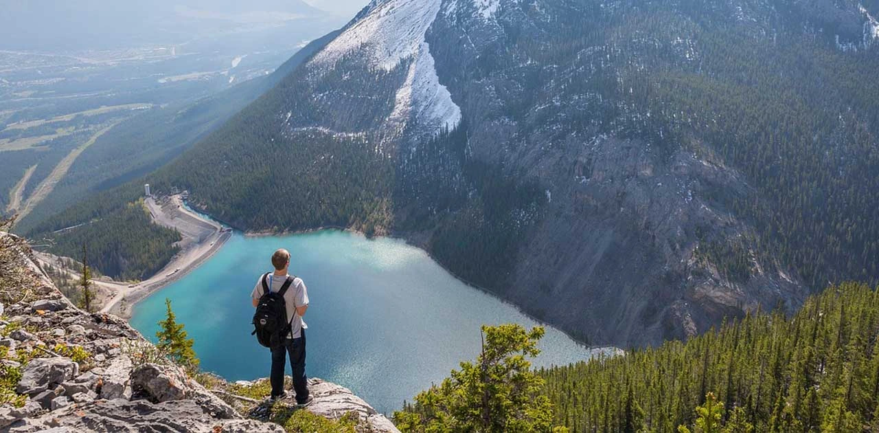
Big Sur, located along California’s iconic Highway 1, is one of the most breathtaking backpacking destinations in the western United States. With its dramatic cliffs, ancient redwoods, and wild coastal scenery, this rugged stretch of central California attracts outdoor enthusiasts year-round. Whether you’re a weekend hiker, a solo traveler looking for solitude, or a budget backpacker in search of remote trails, Big Sur delivers both challenge and tranquility.
This guide covers everything you need to know for a successful backpacking trip in Big Sur. You’ll learn about the best seasons to visit, how to get there affordably, where to go for scenic hikes, and how to pack smartly for this diverse terrain. From the fog-covered ridges of the Ventana Wilderness to quiet beaches below towering bluffs, Big Sur offers experiences that are both raw and unforgettable.
Why Backpacking in Big Sur Is Worth It
Big Sur’s dramatic landscape makes it one of California’s most coveted backpacking regions. Few places offer such a striking mix of coastal cliffs, deep river canyons, redwood groves, and panoramic ridgelines—all within relatively short hiking distances. The Santa Lucia Mountains rise sharply from the Pacific Ocean, creating a unique ecosystem where coastal and forest habitats meet.
Backpackers come to Big Sur for solitude, scenic beauty, and wildlife encounters. You might spot California condors soaring overhead, hear the howl of coyotes at dusk, or catch a glimpse of gray whales during migration season. Plus, with miles of backcountry trails in Los Padres National Forest and the Ventana Wilderness, you can explore lesser-known routes that often remain quiet even during peak tourist months.
Because much of Big Sur’s interior is only accessible by foot, backpackers can enjoy untouched natural settings far from the busy viewpoints and roadside pullouts. Whether you’re venturing into remote highlands or descending into shaded canyons, the reward is a deep connection with one of California’s last great wilderness areas.
Best Time to Go Backpacking in Big Sur
Timing your trip right can make all the difference in Big Sur, especially when it comes to weather, trail conditions, and crowds. The region has a Mediterranean climate with warm, dry summers and cool, wet winters. However, its coastal location also means fog, wind, and microclimates can impact your trip throughout the year.
- Spring (March to May): A great time for backpacking, as wildflowers bloom and water sources run strong. However, trails may still be muddy or washed out due to winter storms.
- Summer (June to August): Offers dry conditions and long daylight hours, but also higher temperatures in inland areas and more crowds along Highway 1. Coastal fog is common in the mornings.
- Fall (September to November): Arguably the best time to backpack. Trails are dry, temps are moderate, and skies are often clear. Early fall still has flowing creeks and fewer mosquitoes.
- Winter (December to February): Risky for backpacking due to heavy rains, landslides, and trail closures. Some sections of the forest may be inaccessible or dangerous after storms.
For budget travelers, early spring and late fall offer a sweet spot. You’ll dodge summer crowds, enjoy milder weather, and often find better availability in campgrounds or trailhead parking.
How to Get There (and Around on a Budget)
Getting to Big Sur requires some planning, especially since public transportation is limited. However, with the right approach, you can access key trailheads and scenic areas without breaking your budget.
By Car (Most Flexible Option)
- From San Francisco: About 2.5 to 3 hours south via Highway 101 or Highway 1
- From Los Angeles: About 5–6 hours north on Highway 101 or Interstate 5 to Highway 1
Driving gives you the most flexibility, especially if you plan to cache supplies, shuttle between trailheads, or stay in dispersed campgrounds.
By Public Transit (Budget-Friendly but Limited)
- Amtrak: Take the train to Salinas, then use a regional bus or rideshare to get closer to the coast.
- Monterey-Salinas Transit (MST) Route 22: Seasonal service from Monterey to Big Sur stops, including Pfeiffer Big Sur State Park. Service usually runs late spring through fall and is the best budget option if you don’t have a car.
- Rideshare: Services like Uber or Lyft are available in Monterey or Carmel, but coverage fades quickly as you head deeper into Big Sur. Use them to reach major trailheads, not remote areas.
If you’re backpacking a point-to-point route, consider leaving your vehicle at one end and arranging a rideshare or friend drop-off. Hitchhiking is not uncommon in the area but should be approached with caution.
Local Tips for Getting Around
- Parking fills up fast at popular trailheads like Big Sur Station, so arrive early.
- Some forest roads are unpaved and may require high-clearance vehicles. Always check road conditions ahead of time on the Los Padres National Forest website.
- Bring printed maps or downloaded offline GPS apps, as phone service is unreliable in most of the backcountry.
Suggested Backpacking Itineraries
Big Sur’s backcountry has something for everyone—from beginner-friendly routes to strenuous, multi-day loops through remote wilderness. Below are three sample backpacking itineraries to help you plan your trip based on your skill level and time.
3-Day Intro Trip: Pine Ridge Trail to Redwood Camp
This classic out-and-back route starts from Big Sur Station and follows the Pine Ridge Trail to Redwood Camp, roughly 6 miles each way. The hike takes you through redwood groves, ridge views, and creek crossings. Campsites are shaded and near a year-round water source, making it ideal for newer backpackers.
- Trailhead: Big Sur Station
- Distance: ~12 miles round trip
- Highlights: Sykes Hot Springs (currently closed), redwoods, Big Sur River
- Difficulty: Moderate
- Permit: Required (Los Padres National Forest)
5-Day Moderate Trip: Ventana Wilderness Loop
For a more remote experience, try a loop combining Pine Ridge Trail, Coast Ridge Road, and Big Sur Trail. You’ll experience oak-covered ridges, stream valleys, and panoramic views of the Pacific. This loop can be rugged, especially in less-maintained segments, but the solitude is worth the effort.
- Trailheads: Big Sur Station or Bottchers Gap
- Distance: ~35 miles
- Highlights: Terraces, river crossings, high ridgelines
- Difficulty: Moderate to challenging
- Permit: Required
7-Day Full Wilderness Trek: Tassajara Road to Kirk Creek
This ambitious route traverses much of the Ventana Wilderness, combining Tassajara Road, Marble Peak Trail, and finally descending via Kirk Creek Trail. It’s rarely crowded and offers exposure to some of the most remote backcountry in Big Sur. Logistics for drop-off and pickup are more complex but manageable for experienced hikers.
- Trailheads: Tassajara Road to Kirk Creek Trailhead
- Distance: ~50–60 miles
- Highlights: Remote high country, Marble Peak, coastal descent
- Difficulty: Advanced
- Permit: Required
Budget Accommodation Options
While most backpackers in Big Sur stay in the backcountry, there are affordable lodging and camping options near major trailheads.
Campgrounds
- Ventana Campground: Near Big Sur Station; shaded, reservable, and has restrooms
- Kirk Creek Campground: Popular coastal site with dramatic ocean views (book early)
- Plaskett Creek Campground: Ideal for those combining car camping with day hikes
Expect prices between $25–$35 per night, with reservations through Recreation.gov.
Backcountry Camping
All dispersed camping in Los Padres National Forest requires a free wilderness permit. Most sites are primitive—no facilities—so bring a trowel and pack out waste where wag bags aren’t required. Campsites like Redwood Camp, Terrace Creek, and Rainbow Camp are common stops.
Budget Lodges
Nearby hostels or cabins like Riverside Campground & Cabins or Big Sur Campground and Cabins offer affordable lodging for $50–$100 per night in shoulder season, though they fill fast in summer.
Backpacking Costs in Big Sur
Backpacking Big Sur can be very affordable, especially for those willing to carry their own food and camp in the wilderness.
| Expense | Estimated Cost |
|---|---|
| Wilderness permit | Free (required for backcountry) |
| Campground (per night) | $25–$35 |
| Transportation (gas/rideshare) | $30–$80 (round trip from SF/LA) |
| Gear rental (if needed) | $100–$150 for weekend |
| Food and snacks (3–5 days) | $30–$60 |
Cost-saving tips:
- Travel in a group to share transportation costs
- Book campgrounds well in advance to avoid expensive last-minute lodging
- Pack dehydrated meals and refill water in the backcountry instead of buying bottled water
Must-Pack Essentials for Big Sur
Big Sur’s terrain includes dense forest, exposed ridgelines, and damp valleys—so versatile gear is key. Here’s a tailored packing list for 3–7 day trips:
- Lightweight backpack (40–60L)
- Tent or bivy sack (freestanding works best in rocky areas)
- Sleeping bag (20–30°F rating)
- Sleeping pad (compact and insulated)
- Rain jacket and thermal layers (for misty mornings and cool nights)
- Trekking poles (optional but useful on steep or slippery terrain)
- Topographic map and offline GPS app (e.g., Gaia GPS, AllTrails)
- Stove and fuel (Jetboil or pocket stove recommended)
- Water filter or purifier (Sawyer Squeeze or similar)
- Bear bag or odor-proof sack (for critter safety)
- Headlamp with extra batteries
- Sun protection (hat, sunscreen, sunglasses)
- Compact first-aid kit
- Trail permit and printed confirmation
Many of these items are suitable for affiliate linking, especially gear like tents, packs, filters, and sleeping systems.
Top Things to Do for Backpackers
Backpackers in Big Sur are treated to a rich variety of natural attractions:
- Sykes Hot Springs (closed as of now): Once a popular soaking spot, the area is being restored, but nearby campsites are still scenic.
- Cone Peak Trail: Often called the most scenic coastal mountain in the lower 48, it rises nearly 5,000 feet from sea to summit.
- Coast Ridge Trail: Offers sweeping views of the Pacific and can be accessed via the Nacimiento-Fergusson Road.
- Redwood groves: Found along trails like Pine Ridge and Terrace Creek, offering cool shade and towering beauty.
- Boucher Trail Ridge: A lesser-used section near the southern end of the Ventana Wilderness, ideal for solitude and ocean views.
Wildlife sightings may include California condors, bobcats, black-tailed deer, and varied birdlife depending on the season. Always observe from a distance and never feed animals.
Food and Water Tips for Backpackers
Water access in Big Sur varies by season. In spring and early summer, streams like Big Sur River, Pine Ridge Creek, and South Fork Big Sur flow reliably. In late summer and fall, some creeks may run dry, so plan water stops carefully and carry extra in dry zones.
Always filter or purify water using a reliable system like a Sawyer Squeeze, UV purifier, or boiling method. Even clear, cold water may contain harmful bacteria or protozoa.
As for food, lightweight and high-calorie options are best:
- Dehydrated meals or DIY trail mixes
- Nut butters, jerky, and energy bars
- Instant oats or couscous for quick cooking
- Electrolyte packets to stay hydrated and balanced
Avoid foods that require refrigeration or create lots of packaging waste. Store all food and scented items in bear bags or odor-proof sacks and hang them away from camp if possible.
Safety Tips for Backpacking in Big Sur
Backpacking in Big Sur can be incredibly rewarding, but it comes with risks that should not be underestimated. Trail conditions can change rapidly due to erosion, landslides, or overgrown brush, especially after storms. Always check trail reports before heading out and carry a detailed map or offline GPS to avoid wrong turns or unmaintained paths.
Weather in Big Sur is unpredictable. While coastal areas may stay foggy and cool, inland valleys can heat up quickly—often over 90°F in summer. Dress in layers and prepare for both cold evenings and sun exposure during the day. Thunderstorms are rare but can occur during fall and early spring.
Wildlife encounters are generally mild, but black bears have been spotted in some remote regions of the Ventana Wilderness. More commonly, rattlesnakes, ticks, and poison oak are concerns. Stay on trails when possible, shake out gear each morning, and do regular tick checks.
For emergencies, cell service is sparse, especially in canyons and forested areas. Bring a satellite communicator or PLB (personal locator beacon) for longer treks. Leave your itinerary with someone you trust and include expected return time and route details.
Eco-Friendly and Responsible Travel Tips
Big Sur is a fragile ecosystem with increasing visitor impact. Practicing Leave No Trace (LNT) is essential to preserve its wilderness for future travelers. This includes packing out all trash, staying on marked trails, and avoiding shortcuts that cause erosion.
When it comes to food storage, use a bear bag or canister, even if bears are not frequently seen. Rodents and raccoons are crafty and can damage gear while searching for food. Hanging your food away from your tent not only protects wildlife but also your safety.
Limit single-use plastics and opt for reusable containers, water bottles, and biodegradable soap. Avoid disturbing natural features like rock stacks or cutting switchbacks. And always use catholes at least 200 feet from water sources—or better yet, pack out waste with a wag bag when required.
Camp only in designated or already impacted sites. Fires are often banned due to wildfire risk, so bring a backpacking stove and follow all fire regulations from Los Padres National Forest.
Recommended Apps & Tools for Backpackers
Planning and navigating a backpacking trip in Big Sur is much easier with the right digital tools. Since cell service is unreliable in most areas, offline functionality is key.
- Gaia GPS: Excellent for downloading detailed topo maps, creating custom routes, and tracking your hike without reception.
- AllTrails+: Provides offline trail maps and real-time trail condition updates. Great for route planning and user reviews.
- Avenza Maps: Allows you to use georeferenced PDFs of National Forest maps, including official Big Sur and Ventana Wilderness maps.
- Recreation.gov App: Use this to book frontcountry campsites and check permit availability.
- CalFire and USFS Alerts: Useful for checking trail closures, fire bans, and road conditions.
- iNaturalist: Optional for identifying plants and wildlife during your trip—great for nature lovers.
Many of these apps are useful for affiliate linking, especially Gaia GPS and AllTrails+, which offer premium subscriptions.
Frequently Asked Questions
As of now, the Pine Ridge Trail remains partially closed beyond Redwood Camp, and Sykes Hot Springs is not accessible due to trail damage and erosion. Always check the Los Padres National Forest site for updated conditions and trail status before planning your route.
Yes. Wilderness permits are required for any overnight backcountry trip in Los Padres National Forest. They are free but must be reserved in advance through Recreation.gov. Some areas also require campfire permits, even for using a stove.
Most major trails have seasonal creeks or rivers, especially in spring and early summer. Popular sources include the Big Sur River, Pine Ridge Creek, and Terrace Creek. However, you should always carry a water filter and check for recent flow reports since many creeks dry out in late summer and fall.
Both are very common, especially on narrow or overgrown trails. Stick to main paths, wear long pants or gaiters, and do tick checks every night. Learn to identify poison oak—it often lines the edges of trails—and avoid brushing against any unknown vegetation.
Yes, dispersed camping is allowed in Los Padres National Forest, but only in pre-established or durable sites. You must camp at least 200 feet away from water sources, roads, and trails. Avoid creating new fire rings or flattening vegetation.
While bear canisters are not mandatory, they are highly recommended. At the very least, use an odor-proof sack and hang it from a tree at least 10 feet off the ground and 4 feet from the trunk. This helps prevent encounters with raccoons, mice, and other animals.
Yes, many experienced hikers backpack solo. However, it’s critical to leave your trip plan with someone, carry offline maps or a GPS, and bring a satellite communicator if you’re heading into remote areas. Trails can be rugged, and assistance may be far away if something goes wrong.
Usually not. Big Sur frequently implements fire bans due to extreme wildfire risk. Even stoves may be restricted during high fire danger periods. Always check the current USFS fire restrictions and be prepared to go stove-free if conditions require.
Use a cathole method at least 6–8 inches deep and 200 feet from water, trails, or campsites. In high-use or sensitive areas, carry out your waste using wag bags—some trailheads may even require them. Pack out all toilet paper and hygiene items.
Robert Starke is a graphic designer with a keen eye for detail and a strong background in video editing. Beyond his creative work, he’s an avid traveler and passionate writer who enjoys sharing practical, engaging advice with fellow adventurers. A lifelong animal lover, Robert also writes about pet products for other websites. Here at Traveleon.com, he focuses mainly on camping, hiking, and backpacking—offering firsthand tips, gear guides, and destination insights to help readers make the most of their time outdoors.